3.10.2.5.10 Configuring Animation for Moving Objects Dataset

You can animate a spatiotemporal map layer of a moving objects dataset based on Cesium map events.

The instructions assume that the spatiotemporal map layer is already added to the Cesium Timeline.
  1. Click Menu Icon against the primary layer in the Data tab of the Layers list.
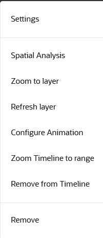
    The context menu of the map layer displays the following options:

    Figure 3-66 Context Menu for a Map Layer

    Description of Figure 3-66 follows
    Description of "Figure 3-66 Context Menu for a Map Layer"
  2. Select Configure Animation.

    The animation settings for the map layer opens.

  3. Switch ON Animate layer based on automatic dataset refresh.
    The dataset animates with the Cesium clock events.
  4. Specify Time between auto refreshes to indicate the frequency of data refresh from the backend. This configuration also determines the smoothness and speed of the temporal animation.
    Also, note the following:
    • Spatial Studio displays a default frequency value which is same as the Data Change Rate value configured on the Spatiotemporal dataset used for the visualization.
    • All the map layers added to the timeline can individually have their own refresh or animation intervals.
    • The parameter ignores all the tick events from the timeline if the Cesium clock current time is less than previousRefreshTime + x seconds (or any other time unit). For example, if a dataset is supposed to refresh every 30 seconds, then configure this value in Time between auto refreshes so that even if the Cesium clock continues to throw tick events for all layers, this layer will ignore any such events.
  5. Specify a Time Unit.
  6. Specify How much data to load, the trail length of your moving object. A trail length value of N indicates that Spatial Studio must fetch the recent N units (unit value as specified in the following step) of data of the moving object during every refresh.

    Tip:

    If the underlying database table or view contains millions of records, you can limit the map animation to display only the most recent N units of data as configured in Trail Length.

    Note that Spatial Studio displays a default trail length value which is 15 times the Data Change Rate value configured on the Spatiotemporal dataset and is rounded to the nearest integer.

  7. Specify a Time Unit for the trail length.

    The animation settings are configured and you can view the animation of moving objects on the map.

    Note:

    You can choose a symbol and color for your moving object. However, ensure that the symbol you select adheres to the conditions explained in Characteristics of Spatiotemporal Map Layers for Moving Objects Dataset.