16 Oracle Spatial
This chapter provides a reference and guide to using the Oracle Spatial cartridge, which extends Oracle Continuous Query Language (Oracle CQL) to provide advanced spatial features for location-enabled applications.
You can use Oracle Spatial types, methods, fields, and constructors in Oracle CQL queries and views as you would Oracle CQL native types when building Oracle Event Processing applications.
This chapter includes the following sections:
For more information, see:
16.1 Understanding Oracle Spatial
Oracle Spatial is an option for Oracle Database that provides advanced spatial features to support high-end geographic information systems (GIS) and location-enabled business intelligence solutions (LBS).
Oracle Spatial is an optional data cartridge which allows you to write Oracle CQL queries and views that seamlessly interact with Oracle Spatial classes in your Oracle Event Processing application.
Using Oracle Spatial, you can configure Oracle CQL queries that perform the most important geographic domain operations such as storing spatial data, performing proximity and overlap comparisons on spatial data, and integrating spatial data with the Oracle Event Processing server by providing the ability to index on spatial data.
To use Oracle Spatial, you require a working knowledge of the Oracle Spatial API. For more information about Oracle Spatial, see:
-
Product overview:
http://www.oracle.com/technology/products/spatial/index.html -
Oracle Spatial documentation:
http://www.oracle.com/pls/db112/portal.portal_db?selected=7&frame=#oracle_spatial_and_location_information -
Oracle Spatial Java API reference:
http://download.oracle.com/docs/cd/E11882_01/appdev.112/e11829/toc.htm
This section describes:
16.1.1 Data Cartridge Name
Oracle Spatial uses the cartridge ID com.oracle.cep.cartrdiges.spatial and registers the server-scoped reserved link name spatial.
Use the spatial link name to associate an Oracle Spatial method call with the Oracle Spatial application context.
For more information, see:
16.1.2 Scope
Oracle Spatial is based on the Oracle Spatial Java API. Oracle Spatial exposes Oracle Spatial functionality in the com.oracle.cep.cartridge.spatial.Geometry class. Oracle Spatial functionality that is not in the Oracle Spatial Java API is not accessible from Oracle Spatial.
Using Oracle Spatial, your Oracle CQL queries may access the Oracle Spatial functionality that Table 16-1 describes.
Table 16-1 Oracle Spatial Scope
| Oracle Spatial Feature | Scope |
|---|---|
|
Geometry Types |
The following geometry types from the Oracle Spatial Java API:
The following geometry operations:
For more information, see: |
|
Coordinate Systems |
For more information, see Section 16.1.2.3, "Ordinates and Coordinate Systems and the SDO_SRID". |
|
Geometric Index |
For more information, see Section 16.1.2.4, "Geometric Index". |
|
Geometric Relation Operators |
For more information, see Section 16.1.2.5, "Geometric Relation Operators". |
|
Geometric Filter Operators |
For more information, see Section 16.1.2.6, "Geometric Filter Operators". |
|
Geometry API |
For a complete list of the methods that |
For more information on how to access these Oracle Spatial features using Oracle Spatial, see Section 16.2, "Using Oracle Spatial".
16.1.2.1 Geometry Types
The Oracle Spatial data model consists of geometries. A geometry is an ordered sequence of vertices. The semantics of the geometry are determined by its type.
Oracle Spatial allows you to access the following Oracle Spatial types directly in Oracle CQL queries and views:
-
SDO_GTYPES: Oracle Spatial supports the following geometry types:-
2D points
-
2D simple polygons
-
2D rectangles
Table 16-2 describes the geometry types from the
com.oracle.cep.cartridge.spatial.Geometryclass that you can use. -
-
SDO_ELEMENT_INFO: You can create the Element Info array using:-
com.oracle.cep.cartridge.spatial.Geometry.createElemInfostatic method -
einfogeneratorfunction
For more information, see Section 16.1.2.2, "Element Info Array".
-
-
ORDINATES: You can create the ordinates using the Oracle Spatialordsgeneratorfunction.For more information, see Section 16.1.2.3, "Ordinates and Coordinate Systems and the SDO_SRID".
For more information, see:
16.1.2.2 Element Info Array
The Element Info attribute is defined using a varying length array of numbers. This attribute specifies how to interpret the ordinates stored in the Ordinates attribute.
Oracle Spatial provides the following helper function for generating Element Info attribute values:
com.oracle.cep.cartridge.spatial.Geometry.createElemInfo(int SDO_STARTING_OFFSET, int SDO_ETYPE , int SDO_INTERPRETATION)
You can also use the einfogenerator function.
For more information, see:
-
"SDO_ELEM_INFO" in the Oracle Spatial Developer's Guide.
16.1.2.3 Ordinates and Coordinate Systems and the SDO_SRID
Table 16-3 lists the coordinate systems that Oracle Spatial supports by default and the SDO_SRID value that identifies each coordinate system.
Table 16-3 Oracle Spatial Coordinate Systems
| Coordinate System | SDO_SRID | Description |
|---|---|---|
|
Cartesian |
0 |
Cartesian coordinates are coordinates that measure the position of a point from a defined origin along axes that are perpendicular in the represented space. |
|
Geodetic (WGS84) |
8307 |
Geodetic coordinates (sometimes called geographic coordinates) are angular coordinates (longitude and latitude), closely related to spherical polar coordinates, and are defined relative to a particular Earth geodetic datum. This is the default coordinate system in Oracle Spatial. |
You can specify the SDO_SRID value as an argument to each Oracle Spatial method and constructor you call or you can configure the SDO_SRID in the Oracle Spatial application context once and use com.oracle.cep.cartridge.spatial.Geometry methods without having to set the SDO_SRID as an argument each time. Using the application context, you can also specify any coordinate system that Oracle Spatial supports.
Note:
If you use acom.oracle.cep.cartridge.spatial.Geometry method that does not take an SDO_SRID value, then you must use the Oracle Spatial application context. For example, the following method call will cause a runtime exception:
com.oracle.cep.cartridge.spatial.Geometry.createPoint(lng, lat)
Instead, you must use the spatial link name to associate the method call with the Oracle Spatial application context:
com.oracle.cep.cartridge.spatial.Geometry.createPoint@spatial(lng, lat)
If you use a Geometry method that takes an SDO_SRID value, then the use of the spatial link name is optional. For example, both the following method calls are valid:
com.oracle.cep.cartridge.spatial.Geometry.createPoint(8307, lng, lat)
com.oracle.cep.cartridge.spatial.Geometry.createPoint@spatial(lng, lat)
For more information, see Section 16.1.4, "Oracle Spatial Application Context".
Ordinates define the array of coordinates for a geometry using a double array. Oracle Spatial provides the ordsgenerator helper function for generating the array of coordinates. For syntax, see "ordsgenerator".
For more information, see:
-
"SDO_SRID" in the Oracle Spatial Developer's Guide
-
"Coordinate Systems (Spatial Reference Systems)" in the Oracle Spatial Developer's Guide
-
Section 16.2.6, "How to Use the Default Geodetic Coordinates"
16.1.2.4 Geometric Index
Oracle Spatial uses a spatial index to implement the primary filter. The purpose of the spatial index is to quickly create a subset of the data and reduce the processing burden on the secondary filter.
A spatial index, like any other index, provides a mechanism to limit searches, but in this case the mechanism is based on spatial criteria such as intersection and containment.
Oracle Spatial uses R-Tree indexing for the default indexing mechanism. A spatial R-tree index can index spatial data of up to four dimensions. An R-tree index approximates each geometry by a single rectangle that minimally encloses the geometry (called the Minimum Bounding Rectangle, or MBR)
For more information, see:
-
"Indexing of Spatial Data" in the Oracle Spatial Developer's Guide
16.1.2.5 Geometric Relation Operators
Oracle Spatial supports the following Oracle Spatial geometric relation operators:
You can use any of these operators in either the Oracle CQL query projection clause or where clause.
When you use a geometric relation operator in the where clause of an Oracle CQL query, Oracle Spatial enables Rtree indexing on the relation specified in the where clause.
Oracle Spatial supports only geometric relations between point and other geometry types.
For more information, see Section 16.2.4, "How to Use Geometry Relation Operators".
16.1.2.6 Geometric Filter Operators
Oracle Spatial supports the following Oracle Spatial geometric filter operators:
These filter operators perform primary filtering and so they may only appear in an Oracle CQL query where clause.
These filter operators use the spatial index to identify the set of spatial objects that are likely to interact spatially with the given object.
For more information, see:
16.1.2.7 Geometry API
Oracle Spatial is based on the Oracle Spatial Java API. Oracle Spatial exposes Oracle Spatial functionality in the com.oracle.cep.cartridge.spatial.Geometry class. This Geometry class also extends oracle.spatial.geometry.J3D_Geometry.
Although Oracle Spatial supports only 2D geometries, for efficiency, the Geometry class uses some J3D_Geometry methods. The Geometry class automatically zero-pads the Z coordinates for J3D_Geometry methods.
Oracle Spatial functionality inaccessible from the Geometry class (or not conforming to the scope and geometry types that Oracle Spatial supports) is inaccessible from Oracle Spatial.
This section describes:
-
Section 16.1.2.7.1, "com.oracle.cep.cartridge.spatial.Geometry Methods"
-
Section 16.1.2.7.2, "oracle.spatial.geometry.JGeometry Methods"
For more information, see:
Note:
To simplify Oracle Spatial type names, you can use aliases as Section 2.7.2, "Defining Aliases Using the Aliases Element" describes.16.1.2.7.1 com.oracle.cep.cartridge.spatial.Geometry Methods
Table 16-4 lists the public methods that the Geometry class provides.
Table 16-4 Oracle Spatial Geometry Methods
| Type | Method |
|---|---|
|
Buffers |
|
|
Distance |
|
|
Element information |
|
|
Geometries |
|
|
Linear polygons |
|
|
Minimum Bounding Rectangle (MBR) |
|
|
Points |
|
|
Rectangles |
|
|
Type and type conversion |
Note:
Geometry class methods are case sensitive and you must use them in the case shown.Note:
If you use acom.oracle.cep.cartridge.spatial.Geometry method that does not take an SDO_SRID value, then you must use the Oracle Spatial application context. For example, the following method call will cause a runtime exception:
com.oracle.cep.cartridge.spatial.Geometry.createPoint(lng, lat)
Instead, you must use the spatial link name to associate the method call with the Oracle Spatial application context:
com.oracle.cep.cartridge.spatial.Geometry.createPoint@spatial(lng, lat)
If you use a Geometry method that takes an SDO_SRID value, then the use of the spatial link name is optional. For example, both the following method calls are valid:
com.oracle.cep.cartridge.spatial.Geometry.createPoint(8307, lng, lat)
com.oracle.cep.cartridge.spatial.Geometry.createPoint@spatial(lng, lat)
For more information, see Section 16.1.4, "Oracle Spatial Application Context".
16.1.2.7.2 oracle.spatial.geometry.JGeometry Methods
The following JGeometry public methods are applicable to Oracle Spatial:
-
double area(double tolerance): returns the total planar surface area of a 2D geometry. -
double length(double tolerance): returns the perimeter of a 2D geometry. All edge lengths are added. -
double[] getMBR(): returns the Minimum Bounding Rectangle (MBR) of this geometry. It returns a double array containing theminX,minY,maxX, andmaxYvalue of the MBR for 2D.
For more information, see:
16.1.3 Datatype Mapping
The Oracle Spatial cartridge supports one data type: com.oracle.cep.cartridge.spatial.Geometry.
For a complete list of the methods that com.oracle.cep.cartridge.spatial.Geometry provides, see Section 16.1.2.7, "Geometry API".
16.1.4 Oracle Spatial Application Context
You can define an application context for an instance of Oracle Spatial and propagate this application context at runtime. This allows you to associate specific Oracle Spatial application defaults (such as an SDO_SRID) with a particular Oracle Spatial instance.
Before you can define an Oracle Spatial application context, edit your Oracle Event Processing application EPN assembly file to add the required namespace and schema location entries as Example 16-1 shows:
Example 16-1 EPN Assembly File: Oracle Spatial Namespace and Schema Location
<?xml version="1.0" encoding="UTF-8"?>
<beans xmlns="http://www.springframework.org/schema/beans"
       xmlns:xsi="http://www.w3.org/2001/XMLSchema-instance"
       xmlns:osgi="http://www.springframework.org/schema/osgi"
       xmlns:wlevs="http://www.bea.com/ns/wlevs/spring"
       xmlns:spatial="http://www.oracle.com/ns/ocep/spatial/"
       xsi:schemaLocation="
  http://www.springframework.org/schema/beans
  http://www.springframework.org/schema/beans/spring-beans.xsd
  http://www.springframework.org/schema/osgi
  http://www.springframework.org/schema/osgi/spring-osgi.xsd
  http://www.bea.com/ns/wlevs/spring
  http://www.bea.com/ns/wlevs/spring/spring-wlevs-v11_1_1_6.xsd"
  http://www.oracle.com/ns/ocep/spatial
  http://www.oracle.com/ns/ocep/spatial/ocep-spatial.xsd">
Example 16-2 shows how to create a spatial context named SpatialGRS80 in an EPN assembly file using the Geodetic Reference System 1980 (GRS80) coordinate system.
Example 16-2 spatial:context Element in EPN Assembly File
<spatial:context id="SpatialGRS80" srid="4269" sma="6378137" rof="298.25722101" />
Example 16-3 shows how to reference a spatial:context in an Oracle CQL query. In this case, the query uses link name SpatialGRS80 (defined in Example 16-2) to propagate this application context to Oracle Spatial. The spatial:context attribute settings of SpatialGRS80 are applied to the createPoint method call.
Example 16-3 Referencing spatial:context in an Oracle CQL Query
<view  id="createPoint">
    select com.oracle.cep.cartridge.spatial.Geometry.createPoint@SpatialGRS80(
        lng, lat)
    from CustomerPos[NOW]
</view>
For more information (including a complete list of all spatial:context attributes), see "How to Configure Oracle Spatial Application Context" in the Oracle Fusion Middleware Developer's Guide for Oracle Event Processing for Eclipse.
Note:
If you use acom.oracle.cep.cartridge.spatial.Geometry method that does not take an SDO_SRID value, then you must use the Oracle Spatial application context. For example, the following method call will cause a runtime exception:
com.oracle.cep.cartridge.spatial.Geometry.createPoint(lng, lat)
Instead, you must use the spatial link name to associate the method call with the Oracle Spatial application context:
com.oracle.cep.cartridge.spatial.Geometry.createPoint@spatial(lng, lat)
If you use a Geometry method that takes an SDO_SRID value, then the use of the spatial link name is optional. For example, both the following method calls are valid:
com.oracle.cep.cartridge.spatial.Geometry.createPoint(8307, lng, lat)
com.oracle.cep.cartridge.spatial.Geometry.createPoint@spatial(lng, lat)
For more information, see Section 16.1.2.7, "Geometry API".
16.2 Using Oracle Spatial
This section describes common use-cases that highlight how you can use Oracle Spatial in your Oracle Event Processing applications, including:
-
Section 16.2.1, "How to Access the Geometry Types That the Oracle Spatial Java API Supports"
-
Section 16.2.3, "How to Access Geometry Type Public Methods and Fields"
-
Section 16.2.6, "How to Use the Default Geodetic Coordinates"
For more information, see Section 16.1.2.7, "Geometry API".
16.2.1 How to Access the Geometry Types That the Oracle Spatial Java API Supports
This procedure describes how to access Oracle Spatial geometry types SDO_GTYPE, SDO_ELEMENT_INFO, and ORDINATES using Oracle Spatial in an Oracle CQL query.
To access the geometry types that the Oracle Spatial Java API supports:
-
Import the package
com.oracle.cep.cartridge.spatialinto your Oracle Event Processing application'sMANIFEST.MFfile.For more information, see "How to Import a Package" in the Oracle Fusion Middleware Developer's Guide for Oracle Event Processing for Eclipse.
-
Define your Oracle Event Processing application event type using the appropriate Oracle Spatial data types.
Example 16-4 shows how to define event type
MySpatialEventwith two event propertiesxandyof typecom.oracle.cep.cartridge.spatial.Geometry.Example 16-4 Oracle Event Processing Event Using Oracle Spatial Types
<wlevs:event-type-repository>
    <wlevs:event-type type-name="MySpatialEvent">
        <wlevs:properties>
            <wlevs:property name="x" type="com.oracle.cep.cartridge.spatial.Geometry"/>
            <wlevs:property name="y" type="com.oracle.cep.cartridge.spatial.Geometry"/>
        </wlevs:properties>
    </wlevs:event-type>
</wlevs:event-type-repository>
You can use these event properties in an Oracle CQL query like this:
CONTAIN@spatial(x, y, 20.0d)
For more information, see "Defining and Using Event Types" in the Oracle Fusion Middleware Developer's Guide for Oracle Event Processing for Eclipse.
-
Choose an
SDO_GTYPE, for example,GTYPE_POLYGON.For more information, see Section 16.1.2.1, "Geometry Types".
-
Choose the Element Info appropriate for your ordinates.
For more information, see Section 16.1.2.2, "Element Info Array"
-
Define your coordinate values.
For more information, see Section 16.1.2.3, "Ordinates and Coordinate Systems and the SDO_SRID".
-
Create your Oracle CQL query as Example 16-5 shows.
Example 16-5 Oracle CQL Query Using Oracle Spatial Geometry Types
view id="ShopGeom">
    select  com.oracle.cep.cartridge.spatial.Geometry.createGeometry@spatial(
        com.oracle.cep.cartridge.spatial.Geometry.GTYPE_POLYGON,
        com.oracle.cep.cartridge.spatial.Geometry.createElemInfo(1, 1003, 1),
        ordsgenerator@spatial(
            lng1, lat1, lng2, lat2, lng3, lat3,
            lng4, lat4, lng5, lat5, lng6, lat6
        )
    ) as geom
    from ShopDesc
</view>
16.2.2 How to Create a Geometry
You can use Oracle Spatial to create a geometry in an Oracle CQL query by invoking:
-
static methods in
com.oracle.cartridge.spatial.Geometry -
methods in
oracle.spatial.geometry.JGeometrythat conform to the scope and geometry types that Oracle Spatial supports.
For more information, see Section 16.1.2.7, "Geometry API".
Using a Static Method in the Oracle Spatial Geometry Class
Example 16-6 shows how to create a point geometry using a static method in com.oracle.cartridge.spatial.Geometry. In this case, you must use a link (@spatial) to identify the data cartridge that provides this class. The advantage of using this approach is that the Oracle Spatial application context is applied to set the SRID and other Oracle Spatial options, either by default or based on an application context you configure (see Section 16.1.4, "Oracle Spatial Application Context").
Example 16-6 Creating a Point Geometry Using a Geometry Static Method
<view  id="CustomerPosGeom">
    select com.oracle.cep.cartridge.spatial.Geometry.createPoint@spatial(
        lng, lat) as geom
    from CustomerPos[NOW]
</view>
For more information, see Section 16.1.2.1, "Geometry Types".
16.2.3 How to Access Geometry Type Public Methods and Fields
Using Oracle Spatial, you can access the public member functions and public member fields of Oracle Spatial classes directly in Oracle CQL.
Oracle Spatial functionality inaccessible from the Geometry class (or not conforming to the scope and geometry types that Oracle Spatial supports) is inaccessible from Oracle Spatial.
In Example 16-7, the view ShopGeom creates an Oracle Spatial geometry called geom. The view shopMBR calls JGeometry static method getMBR which returns a double[] as stream element mbr. The query qshopMBR accesses this double[] using regular Java API.
Example 16-7 Accessing Geometry Type Public Methods and Fields
<view id="ShopGeom">
    select  com.oracle.cep.cartridge.spatial.Geometry.createGeometry@spatial(
        com.oracle.cep.cartridge.spatial.Geometry.GTYPE_POLYGON,
        com.oracle.cep.cartridge.spatial.Geometry.createElemInfo(1, 1003, 1),
        ordsgenerator@spatial(
            lng1, lat1, lng2, lat2, lng3, lat3,
            lng4, lat4, lng5, lat5, lng6, lat6
        )
    ) as geom
    from ShopDesc
</view>
<view  id=”shopMBR”>
    select geom.getMBR() as mbr
    from ShopGeom
</view>
<query  id=”qshopMBR”>
    select mbr[0], mbr[1], mbr[2], mbr[3]
    from shopMBR
</query>
For more information, see:
16.2.4 How to Use Geometry Relation Operators
Using Oracle Spatial, you can access the following Oracle Spatial geometry relation operators in either the WHERE or SELECT clause of an Oracle CQL query:
In Example 16-8, the view op_in_where uses the CONTAIN geometry relation operator in the WHERE clause: in this case, Oracle Spatial uses R-Tree indexing. The view op_in_proj uses CONTAIN in the SELECT clause.
Example 16-8 Using Geometry Relation Operators
<view id="op_in_where">
    RStream(
        select
            loc.customerId,
            shop.shopId
        from
            LocGeomStream[NOW] as loc,
            ShopGeomRelation as shop
        where
            CONTAIN@spatial(shop.geom, loc.curLoc, 5.0d) = true
    )
</view>
<view id="op_in_proj">
    RStream(
        select
            loc.customerId,
            shop.shopId,
            CONTAIN@spatial(shop.geom, loc.curLoc, 5.0d)
        from
            LocGeomStream[NOW] as loc,
            ShopGeomRelation as shop
    )
</view>
For more information, see Section 16.1.2.5, "Geometric Relation Operators".
16.2.5 How to Use Geometry Filter Operators
Using Oracle Spatial, you can access the following Oracle Spatial geometry filter operators in the WHERE clause of an Oracle CQL query:
In Example 16-9, the view filter uses the FILTER geometry filter operator in the WHERE clause.
Example 16-9 Using Geometry Filter Operators
<view id="filter">
    RStream(
        select loc.customerId, shop.shopId
        from LocGeomStream[NOW] as loc, ShopGeomRelation as shop
        where FILTER@spatial(shop.geom, loc.curLoc, 5.0d) = true
    )
</view>
For more information, see Section 16.1.2.6, "Geometric Filter Operators".
16.2.6 How to Use the Default Geodetic Coordinates
When you create an Oracle CQL query using the default Oracle Spatial application context, the default SRID will be set to CARTESIAN.
As Example 16-10 shows, the createPoint method call uses the default link (@spatial). This guarantees that the default Oracle Spatial application context is applied.
Example 16-10 Using the Default Geodetic Coordinates in an Oracle CQL Query
<view  id="createPoint">
    select com.oracle.cep.cartridge.spatial.Geometry.createPoint@spatial(
        lng, lat)
    from CustomerPos[NOW]
</view>
For more information, see:
16.2.7 How to Use Other Geodetic Coordinates
This procedure describes how to use the Oracle Spatial application context to specify a geodetic coordinate system other than the default Cartesian geodetic coordinate system in an Oracle CQL query:
For more information, see:
To use other geodetic coordinates:
-
Create an Oracle Spatial application context and define the
sridattribute for the geodetic coordinate system you want to use.Example 16-11 shows how to create a spatial context named
SpatialGRS80in an EPN assembly file using the Geodetic Reference System 1980 (GRS80) coordinate system. -
In your Oracle CQL query, use the id of this
spatial:contextin your links.Example 16-12 shows how to reference a
spatial:contextin an Oracle CQL query. In this case, the query uses link nameSpatialGRS80(defined in Example 16-11) to propagate this application context to Oracle Spatial. Thespatial:contextattribute settings ofSpatialGRS80are applied to thecreatePointmethod call.
ANYINTERACT
Note:
This is an Oracle Spatial geometric relation operator and not a method of thecom.oracle.cep.cartridge.spatial.Geometry class so you invoke this operator as Example 16-13 shows, without a package prefix:
ANYINTERACT@spatial
This operator returns true if the GTYPE_POINT interacts with the geometry, and false otherwise.
This operator takes the following arguments:
-
geom: any supported geometry type. -
key: aGTYPE_POINTgeometry type.The geometry type of this geometry must be
GTYPE_POINTor aRUNTIME_EXCEPTIONwill be thrown. -
tol: the tolerance as adoublevalue.
For more information, see "SDO_ANYINTERACT" in the Oracle Spatial Developer's Guide.
Example 16-27 shows how to use the ANYINTERACT Oracle Spatial geometric relation operator in an Oracle CQL query.
Example 16-13 Oracle CQL Query Using Geometric Relation Operator ANYINTERACT
<view id="op_in_where">
    RStream(
        select
            loc.customerId,
            shop.shopId
        from
            LocGeomStream[NOW] as loc,
            ShopGeomRelation as shop
        where
            ANYINTERACT@spatial(shop.geom, loc.curLoc, 5.0d) = true
    )
</view>
<view id="op_in_proj">
    RStream(
        select
            loc.customerId,
            shop.shopId,
            ANYINTERACT@spatial(shop.geom, loc.curLoc, 5.0d)
        from
            LocGeomStream[NOW] as loc,
            ShopGeomRelation as shop
    )
</view>
bufferPolygon
This com.oracle.cep.cartridge.spatial.Geometry method returns a new com.oracle.cep.cartridge.spatial.Geometry object which is the buffered version of the input oracle.spatial.geometry.JGeometry polygon.
This method takes the following arguments:
-
polygon: anoracle.spatial.geometry.JGeometrypolygon. -
distance: the distance value used for this buffer as adouble.This value is assumed to be in the same unit as the Unit of Projection for projected geometry. If the geometry is geodetic, this buffer width should be in meters.
This method obtains parameters from the Oracle Spatial application context. Consequently, you must use the spatial link name to associate the method call with the Oracle Spatial application context:
com.oracle.cep.cartridge.spatial.Geometry.bufferPolygon@spatial(geom, 1300)
For more information, see Section 16.1.4, "Oracle Spatial Application Context".
Example 16-14 shows how to use the bufferPolygon method. Because this bufferPolygon call depends on the Oracle Spatial application context, it uses the spatial link name.
CONTAIN
Note:
This is an Oracle Spatial geometric relation operator and not a method of thecom.oracle.cep.cartridge.spatial.Geometry class so you invoke this operator as Example 16-13 shows, without a package prefix:
CONTAIN@spatial
This operator returns true if the GTYPE_POINT is contained by the geometry, and false otherwise.
This operator takes the following arguments:
-
geom: any supported geometry type. -
key: aGTYPE_POINTgeometry type.The geometry type of this geometry must be
GTYPE_POINTor aRUNTIME_EXCEPTIONwill be thrown. -
tol: the tolerance as adoublevalue.
For more information, see "SDO_CONTAINS" in the Oracle Spatial Developer's Guide.
Example 16-27 shows how to use the CONTAIN Oracle Spatial geometric relation operator in an Oracle CQL query.
Example 16-15 Oracle CQL Query Using Geometric Relation Operator CONTAIN
<view id="op_in_where">
    RStream(
        select
            loc.customerId,
            shop.shopId
        from
            LocGeomStream[NOW] as loc,
            ShopGeomRelation as shop
        where
            CONTAIN@spatial(shop.geom, loc.curLoc, 5.0d) = true
    )
</view>
<view id="op_in_proj">
    RStream(
        select
            loc.customerId,
            shop.shopId,
            CONTAIN@spatial(shop.geom, loc.curLoc, 5.0d)
        from
            LocGeomStream[NOW] as loc,
            ShopGeomRelation as shop
    )
</view>
createElemInfo
Note:
Alternatively, you can use the functioneinfogenerator. For more information, see "einfogenerator".This com.oracle.cep.cartridge.spatial.Geometry method returns a single element info value as an int[] from the given arguments.
This method takes the following arguments:
-
soffset: the offset, as anint, within the ordinates array where the first ordinate for this element is stored.SDO_STARTING_OFFSETvalues start at 1 and not at 0. Thus, the first ordinate for the first element will be atSDO_GEOMETRY.Ordinates(1). If there is a second element, its first ordinate will be atSDO_GEOMETRY.Ordinates(n* 3 + 2), wherenreflects the position within theSDO_ORDINATE_ARRAYdefinition. -
etype: the type of the element as anint.Oracle Spatial supports
SDO_ETYPEvalues 1, 1003, and 2003 are considered simple elements (not compound types). They are defined by a single triplet entry in the element info array. These types are:-
1: point.
-
1003: exterior polygon ring (must be specified in counterclockwise order).
-
2003: interior polygon ring (must be specified in clockwise order).
These types are further qualified by the
SDO_INTERPRETATION.Note:
You cannot mix 1-digit and 4-digitSDO_ETYPEvalues in a single geometry. -
-
interp: the interpretation as anint.For an SDO_ETYPE that is a simple element (1, 1003, or 2003) the
SDO_INTERPRETATIONattribute determines how the sequence of ordinates for this element is interpreted. For example, a polygon boundary may be made up of a sequence of connected straight line segments.If a geometry consists of more than one element, then the last ordinate for an element is always one less than the starting offset for the next element. The last element in the geometry is described by the ordinates from its starting offset to the end of the ordinates varying length array.
Table 16-5 describes the relationship between
SDO_ETYPEandSDO_INTERPREATION.Table 16-5 SDO_ETYPE and SDO_INTERPRETATION
SDO_ETYPE SDO_INTERPRETATION Description 0
Any numeric value
Used to model geometry types not supported by Oracle Spatial.
1
1
Point type.
1
0
Orientation for an oriented point.
1003 or 2003
1
Simple polygon whose vertices are connected by straight line segments. You must specify a point for each vertex; and the last point specified must be exactly the same point as the first (within the tolerance value), to close the polygon.
For example, for a 4-sided polygon, specify 5 points, with point 5 the same as point 1.
Example 16-16 shows how to use the createElemInfo method.
Example 16-16 Oracle CQL Query Using Geometry.createElemInfo
<view id="ShopGeom">
    select  com.oracle.cep.cartridge.spatial.Geometry.createGeometry@spatial(
        com.oracle.cep.cartridge.spatial.Geometry.GTYPE_POLYGON,
        com.oracle.cep.cartridge.spatial.Geometry.createElemInfo(1, 1003, 1),
        ordsgenerator@spatial(
            lng1, lat1, lng2, lat2, lng3, lat3,
            lng4, lat4, lng5, lat5, lng6, lat6
        )
    ) as geom
    from ShopDesc
</view>
createGeometry
This com.oracle.cep.cartridge.spatial.Geometry method returns a new 2D oracle.cep.cartridge.spatial.Geometry object.
This method takes the following arguments:
-
gtype: the geometry type as anint.For more information, see Table 16-2.
-
eleminfo: the geometry element info as anint[].For more information, see "createElemInfo".
-
ordinates: the geometry ordinates as adouble[]. -
srid: the optionalSDO_SRIDof the geometry as anint.If you omit the
sridparameter, then this method obtains parameters from the Oracle Spatial application context. Consequently, you must use thespatiallink name to associate the method call with the Oracle Spatial application context:com.oracle.cep.cartridge.spatial.Geometry.createGeometry@spatial(gtype, eleminfo, ordinates)
For more information, see Section 16.1.4, "Oracle Spatial Application Context".
Example 16-17 shows how to use the createGeometry method. Because this createGeometry call does not include the srid argument, it uses the spatial link name to associate the method call with the Oracle Spatial application context.
Example 16-17 Oracle CQL Query Using Geometry.createGeometry
<view id="ShopGeom">
    select  com.oracle.cep.cartridge.spatial.Geometry.createGeometry@spatial(
        com.oracle.cep.cartridge.spatial.Geometry.GTYPE_POLYGON,
        com.oracle.cep.cartridge.spatial.Geometry.createElemInfo(1, 1003, 1),
        ordsgenerator@spatial(
            lng1, lat1, lng2, lat2, lng3, lat3,
            lng4, lat4, lng5, lat5, lng6, lat6
        )
    ) as geom
    from ShopDesc
</view>
createLinearPolygon
This com.oracle.cep.cartridge.spatial.Geometry method returns a new com.oracle.cep.cartridge.spatial.Geometry object which is a 2D simple linear polygon without holes. If the coordinate array does not close itself (the last coordinate is not the same as the first) then this method copies the first coordinate and appends this coordinate value to the end of the input coordinates array.
To create a simple linear polygon without holes, use the following arguments:
-
coords: the coordinates of the linear polygon as adouble[]. -
srid: the optionalSRIDof the geometry as anint.If you omit the
sridparameter, then this method obtains parameters from the Oracle Spatial application context. Consequently, you must use thespatiallink name to associate the method call with the Oracle Spatial application context:com.oracle.cep.cartridge.spatial.Geometry.createLinearPolygon@spatial(coords)
For more information, see Section 16.1.4, "Oracle Spatial Application Context".
Example 16-18 shows how to use the createLinearPolygon method. Because this createLinearPolygon method call does not include the srid argument, it must use the spatial link name to associate the method call with the Oracle Spatial application context.
createPoint
This com.oracle.cep.cartridge.spatial.Geometry method returns a new com.oracle.cep.cartridge.spatial.Geometry object which is a 3D point.
This method takes the following arguments:
-
x: the x coordinate of the lower left as adouble. -
y: the y coordinate of the lower left as adouble. -
srid: the optionalSRIDof the geometry as anint.If you omit the
sridparameter, then this method obtains parameters from the Oracle Spatial application context. Consequently, you must use thespatiallink name to associate the method call with the Oracle Spatial application context:com.oracle.cep.cartridge.spatial.Geometry.createPoint@spatial(x, y)
For more information, see Section 16.1.4, "Oracle Spatial Application Context".
Example 16-19 shows how to use the createPoint method. Because this createPoint call includes the srid argument, it does not need to use the spatial link name.
createRectangle
This com.oracle.cep.cartridge.spatial.Geometry method returns a new com.oracle.cep.cartridge.spatial.Geometry object which is a 2D rectangle.
This method takes the following arguments:
-
x1: the x coordinate of the lower left as adouble. -
y1: the y coordinate of the lower left as adouble. -
x2: the x coordinate of the upper right as adouble. -
y2: the y coordinate of the upper right as adouble. -
srid: the optionalSRIDof the geometry as anint.If you omit the
sridparameter, then this method obtains parameters from the Oracle Spatial application context. Consequently, you must use thespatiallink name to associate the method call with the Oracle Spatial application context:com.oracle.cep.cartridge.spatial.Geometry.createRectangle@spatial(x1, y1, x2, y2)
For more information, see Section 16.1.4, "Oracle Spatial Application Context".
Example 16-20 shows how to use the createRectangle method. Because this createRectangle method call does not include the srid argument, it must use the spatial link name to associate the method call with the Oracle Spatial application context.
distance
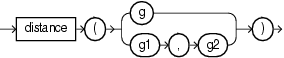
This com.oracle.cep.cartridge.spatial.Geometry method calculates the distance between two geometries as a double.
To calculate the distance between a given com.oracle.cep.cartridge.spatial.Geometry object and another, use the non-static distance method of the current Geometry object with the following arguments:
-
g: the othercom.oracle.cep.cartridge.spatial.Geometryobject.
To calculate the distance between two com.oracle.cep.cartridge.spatial.Geometry objects, use the static distance method with the following arguments:
-
g1: the firstcom.oracle.cep.cartridge.spatial.Geometryobject. -
g2: the secondcom.oracle.cep.cartridge.spatial.Geometryobject.
In both cases, this method obtains parameters from the Oracle Spatial application context. Consequently, you must use the spatial link name to associate the method call with the Oracle Spatial application context:
com.oracle.cep.cartridge.spatial.Geometry.distance@spatial(geom)
com.oracle.cep.cartridge.spatial.Geometry.distance@spatial(geom1, geom2)
For more information, see Section 16.1.4, "Oracle Spatial Application Context".
Example 16-21 shows how to use the distance method. Because the distance method depends on the Oracle Spatial application context, it must use the spatial link name.
Example 16-21 Oracle CQL Query Using Geometry.distance
<view id="LocGeomStream" schema="customerId curLoc">
    select
        customerId,
        com.oracle.cep.cartridge.spatial.Geometry.createRectangle(x1, y1, x2, y2, 8307)
    from
        CustomerLocStream
    where
        com.oracle.cep.cartridge.spatial.Geometry.distance@spatial(geom1, geom2) < 5
</view>
einfogenerator
Note:
This is an Oracle CQL function and not a method of thecom.oracle.cep.cartridge.spatial.Geometry class so you invoke this function as Example 16-22 shows, without a package prefix:
einfogenerator@spatial
Alternatively, you can use the Geometry method createElemInfo. For more information, see "createElemInfo".
This function returns a single element info value as an int[] from the given arguments.
This function takes the following arguments:
-
offset: the offset, as anint, within the ordinates array where the first ordinate for this element is stored.SDO_STARTING_OFFSETvalues start at 1 and not at 0. Thus, the first ordinate for the first element will be atSDO_GEOMETRY.Ordinates(1). If there is a second element, its first ordinate will be atSDO_GEOMETRY.Ordinates(n* 3 + 2), wherenreflects the position within theSDO_ORDINATE_ARRAYdefinition. -
etype: the type of the element as anint.Oracle Spatial supports
SDO_ETYPEvalues 1, 1003, and 2003 are considered simple elements (not compound types). They are defined by a single triplet entry in the element info array. These types are:-
1: point.
-
1003: exterior polygon ring (must be specified in counterclockwise order).
-
2003: interior polygon ring (must be specified in clockwise order).
These types are further qualified by the
SDO_INTERPRETATION.Note:
You cannot mix 1-digit and 4-digitSDO_ETYPEvalues in a single geometry. -
-
interp: the interpretation as anint.For an
SDO_ETYPEthat is a simple element (1, 1003, or 2003) theSDO_INTERPRETATIONattribute determines how the sequence of ordinates for this element is interpreted. For example, a polygon boundary may be made up of a sequence of connected straight line segments.If a geometry consists of more than one element, then the last ordinate for an element is always one less than the starting offset for the next element. The last element in the geometry is described by the ordinates from its starting offset to the end of the ordinates varying length array.
Table 16-6 describes the relationship between
SDO_ETYPEandSDO_INTERPREATION.Table 16-6 SDO_ETYPE and SDO_INTERPRETATION
SDO_ETYPE SDO_INTERPRETATION Description 0
Any numeric value
Used to model geometry types not supported by Oracle Spatial.
1
1
Point type.
1
0
Orientation for an oriented point.
1003 or 2003
1
Simple polygon whose vertices are connected by straight line segments. You must specify a point for each vertex; and the last point specified must be exactly the same point as the first (within the tolerance value), to close the polygon.
For example, for a 4-sided polygon, specify 5 points, with point 5 the same as point 1.
Example 16-22 shows how to use the oeinfogenerator function to create the element information for a geometry.
Example 16-22 Oracle CQL Query Using Oracle Spatial Geometry Types
view id="ShopGeom">
    select  com.oracle.cep.cartridge.spatial.Geometry.createGeometry@spatial(
        com.oracle.cep.cartridge.spatial.Geometry.GTYPE_POLYGON,
        einfogenerator@spatial(1, 1003, 1),
        ordsgenerator@spatial(
            lng1, lat1, lng2, lat2, lng3, lat3,
            lng4, lat4, lng5, lat5, lng6, lat6
        )
    ) as geom
    from ShopDesc
</view>
FILTER
Note:
This is an Oracle Spatial geometric filter operator and not a method of thecom.oracle.cep.cartridge.spatial.Geometry class so you invoke this operator as Example 16-13 shows, without a package prefix:
FILTER@spatial
This operator returns true for object pairs that are non-disjoint, and false otherwise.
This operator takes the following arguments:
-
key: aGTYPE_POINTgeometry type.The geometry type of this geometry must be
GTYPE_POINTor aRUNTIME_EXCEPTIONwill be thrown. -
tol: the tolerance as adoublevalue.
For more information, see "SDO_FILTER" in the Oracle Spatial Developer's Guide.
Example 16-27 shows how to use the FILTER Oracle Spatial geometric filter operator in an Oracle CQL query.
get2dMbr
This com.oracle.cep.cartridge.spatial.Geometry method returns the Minimum Bounding Rectangle (MBR) of a given Geometry as a double[][] that contains the following values:
-
[0][0]:minX -
[0][1]:maxX -
[1][0]:minY -
[1][1]:maxY
This method takes the following arguments:
-
geom: thecom.oracle.cep.cartridge.spatial.Geometryobject.
Example 16-24 shows how to use the get2dMbr method.
INSIDE
Note:
This is an Oracle Spatial geometric relation operator and not a method of thecom.oracle.cep.cartridge.spatial.Geometry class so you invoke this operator as Example 16-13 shows, without a package prefix:
INSIDE@spatial
This operator returns true if the GTYPE_POINT is inside the geometry, and false otherwise.
This operator takes the following arguments:
-
geom: any supported geometry type. -
key: aGTYPE_POINTgeometry type.The geometry type of this geometry must be
GTYPE_POINTor aRUNTIME_EXCEPTIONwill be thrown. -
tol: the tolerance as adoublevalue.
For more information, see "SDO_INSIDE" in the Oracle Spatial Developer's Guide.
Example 16-27 shows how to use the INSIDE Oracle Spatial geometric relation operator in an Oracle CQL query.
Example 16-25 Oracle CQL Query Using Geometric Relation Operator INSIDE
<view id="op_in_where">
    RStream(
        select
            loc.customerId,
            shop.shopId
        from
            LocGeomStream[NOW] as loc,
            ShopGeomRelation as shop
        where
            INSIDE@spatial(shop.geom, loc.curLoc, 5.0d) = true
    )
</view>
<view id="op_in_proj">
    RStream(
        select
            loc.customerId,
            shop.shopId,
            INSIDE@spatial(shop.geom, loc.curLoc, 5.0d)
        from
            LocGeomStream[NOW] as loc,
            ShopGeomRelation as shop
    )
</view>
NN
Note:
This is an Oracle Spatial geometric filter operator and not a method of thecom.oracle.cep.cartridge.spatial.Geometry class so you invoke this operator as Example 16-13 shows, without a package prefix:
NN@spatial
This operator returns the objects (nearest neighbors) from geom that are nearest to key. In determining how near two geometry objects are, the shortest possible distance between any two points on the surface of each object is used.
This function takes the following arguments:
-
geom: any supported geometry type. -
key: aGTYPE_POINTgeometry type.The geometry type of this geometry must be
GTYPE_POINTor aRUNTIME_EXCEPTIONwill be thrown. -
tol: the tolerance as adoublevalue.
For more information, see "SDO_NN" in the Oracle Spatial Developer's Guide.
Example 16-27 shows how to use the NN Oracle Spatial geometric filter operator in an Oracle CQL query.
ordsgenerator
Note:
This is an Oracle CQL function and not a method of thecom.oracle.cep.cartridge.spatial.Geometry class so you invoke this function as Example 16-27 shows, without a package prefix:
ordsgenerator@spatial
This function returns the double array of 2D coordinates that Oracle Spatial requires.
This function takes the following arguments:
-
x1, y1, ... xN, yN: a comma-separated list ofdoublecoordinate values.
Example 16-27 shows how to use the ordsgenerator function to create an Oracle Spatial double array out of six double coordinate values.
Example 16-27 Oracle CQL Query Using Oracle Spatial Geometry Types
view id="ShopGeom">
    select  com.oracle.cep.cartridge.spatial.Geometry.createGeometry@spatial(
        com.oracle.cep.cartridge.spatial.Geometry.GTYPE_POLYGON,
        com.oracle.cep.cartridge.spatial.Geometry.createElemInfo(1, 1003, 1),
        ordsgenerator@spatial(
            lng1, lat1, lng2, lat2, lng3, lat3,
            lng4, lat4, lng5, lat5, lng6, lat6
        )
    ) as geom
    from ShopDesc
</view>
to_Geometry
This com.oracle.cep.cartridge.spatial.Geometry method converts an oracle.spatial.geometry.JGeometry type to a 3D com.oracle.cep.cartridge.spatial.Geometry type. If the given geometry is already a Geometry type and a 3D geometry, then no conversion is done. If the given geometry is a 2D geometry, then the given geometry is converted to 3D by padding z coordinates.
This method takes the following arguments:
-
geom: theoracle.spatial.geometry.JGeometryobject to convert.
Example 16-28 shows how to use the to_Geometry method.
to_JGeometry
This com.oracle.cep.cartridge.spatial.Geometry method converts a com.oracle.cep.cartridge.spatial.Geometry object to an oracle.spatial.geometry.JGeometry 2D type.
This method takes the following arguments:
-
g: thecom.oracle.cep.cartridge.spatial.Geometryobject to convert.
Example 16-29 shows how to use the to_JGeometry method.
WITHINDISTANCE
Note:
This is an Oracle Spatial geometric relation operator and not a method of thecom.oracle.cep.cartridge.spatial.Geometry class so you invoke this operator as Example 16-13 shows, without a package prefix:
WITHINDISTANCE@spatial
This operator returns true if the GTYPE_POINT is within the given distance of the geometry, and false otherwise.
This operator takes the following arguments:
-
geom: any supported geometry type. -
key: aGTYPE_POINTgeometry type.The geometry type of this geometry must be
GTYPE_POINTor aRUNTIME_EXCEPTIONwill be thrown. -
dist: the distance as adoublevalue.
For more information, see "SDO_WITHIN_DISTANCE" in the Oracle Spatial Developer's Guide.
Example 16-27 shows how to use the WITHINDISTANCE Oracle Spatial geometric relation operator in an Oracle CQL query.
Example 16-30 Oracle CQL Query Using Geometric Relation Operator WITHINDISTANCE
<view id="op_in_where">
    RStream(
        select
            loc.customerId,
            shop.shopId
        from
            LocGeomStream[NOW] as loc,
            ShopGeomRelation as shop
        where
            WITHINDISTANCE@spatial(shop.geom, loc.curLoc, 5.0d) = true
    )
</view>
<view id="op_in_proj">
    RStream(
        select
            loc.customerId,
            shop.shopId,
            WITHINDISTANCE@spatial(shop.geom, loc.curLoc, 5.0d)
        from
            LocGeomStream[NOW] as loc,
            ShopGeomRelation as shop
    )
</view>